Mt. Conness (12,590'): Navigational chaos high on the mountain
Sept 14-15, 2000 |

random trip report |
ABSTRACT. An attempt on Mt. Conness is marred by tragicomic route-finding blunders. Thanks to the determination of my climbing partner, and a serendipitous encounter with a mysterious climber, we manage to reach the top.
| Ever since the time last summer when three guys staggered into the Sawmill campground at 10 PM, exhausted beyond the zero, having spent 13 hours getting up and down Mt. Conness, it's held a special attraction for me. And of course for Mike O'Brien. But he has a 9-to-5 job and is about to become a father. So I called Rob Vaterlaus for this mid-week junket. | Rob was a Master's student of mine at UC Berkeley in 1988-89. |
|
We head up to the mountains around noon.
In spite of careful packing I have forgotten my shorts,
so we stop at the K-Mart in Oakdale
and I buy some cutoffs for $4.
Pulling into Lee Vining, we pass the site of Rob's car crash on 395. | A head-on collision with an Australian driving on the wrong side of the road. Fortunately, no one was badly hurt. |
|
We camp in the usual site near Mono Lake.
I make a hasty trip back to Lee Vining to buy a cooking pot,
which I have also somehow forgotten.
 Dawn at the Mono Lake campsite Next morning we're up at six, on the road at 7:30, and on the trail from Saddlebag Lake (10,060') at 8:30. We plan to follow Gordon Ye's route. | Coincidentally, Gordon Ye seems to live in Berkeley and has done some very cool work, including a bicycle route-finding program. |
|
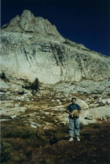
 Rob with $1 K-Mart hat. Mt. Dana in the background We pick up the trail below the dam and follow it down through pine forest to the Carnegie Institute Experimental Station, a boarded-up shack in the middle of the forest.  The Carnegie Institute Experimental Station.
We head for Alpine Lake.
We stay to the right.
Too far to the right.
The main valley splits into three upper valleys;
Alpine lake is in the middle of these, and we're in the rightmost.
 Alpine lake is to the left of the knoll in center. Conness is hidden by the bluff behind it. Rob and I mistakenly ascended to right of the 'false peak' at right.
| I've modified Gordon Ye's map, with the black line showing where I think we actually went on the ascent. We returned by the lower (blue) loop. |
We pass a dried-up puddle, which we dupe ourselves into
thinking is Alpine lake ('Like, maybe this was a really dry year').
In the upper-left part of the valley is a class-3 bluff that
vaguely matches our route on the map,
so we start up it.
 The base of the 'false peak'. We first ascended the slope at base, then climbed around the back. Both were red herrings. About 100 feet up I look again at the map and notice some obvious disparities. It seems like we should be on the cliff-edge at the top of the valley, so we descend the bluff and go there.
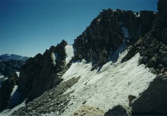
 Top of the Conness Glacier. Mt. Conness is the rightmost hump. From the cliff there is a staggering view of the Conness Glacier, Some hard scrambling puts us on top of the tower. There is indeed a sandy plateau, but it's about 100 feet wide, not a mile. The summit is still very far away. Looking downwards, our vantage point now reveals a large, full-to-the-brim lake: Alpine Lake. We abruptly realize that things have gone terribly, terribly wrong. Pulling out the map, we try to reconstruct what has happened. We're at the upper right corner of a large bowl above Alpine lake. The correct route leads up the bowl and to the left. It's now past 11 AM. We've spent lots of time and energy chasing after false leads. I suggest to Rob that we descend to Alpine Lake and call it a day. Rob suggests that we traverse across the top of the bowl and see what happens.
First we have to get down the 50-foot cliff that rings
the top of the bowl.
I locate a gully and we scramble down,
using some modified rock-climbing moves.
Traversing the bowl is not bad.
We reach the left upper corner,
and are treated to an even better view of the vast Conness glacier.
 Midway across the bowl. The buttress at right is where we saw a climber descending. Above the bowl and to the left is seemingly vertical wall of jumbled rock, 200-300 feet high. We see a mysterious solitary climber descending this, and our paths cross at the base of the wall. We talk for about 5 minutes. He has been hiking since 6 AM, leaving from Sawmill, going around Saddlebag lake, by the Conness Lakes, up the east ridge (we're not really sure what he means) to the summit. He's bubbling over with enthusiasm about the mountain: 'You're going to have SOOOO much fun'. The wall he has just descended, he says, is not really that hard, and leads directly to the summit plateau, from which it's only 400-500 yards to the summit itself. This encounter, of course, galvanizes me. We might actually make it!
 Halfway up the buttress. We gain the summit plateau, this time for real. it's a huge sandy slope, running the 1-mile length of the Conness Ridge and sloping down towards Young Lake to the west. We make careful note of the rocks we came over.  Looking East from the summit plateau. Tioga Peak in center, White Mountains in the distance. A bit of Alpine Lake visible in foreground At the north end of the plateau, connected to it by a 50-foot arete, is the Conness summit block, an imposing mass rising about 100' above the plateau. | An 'arete' is a ridge glaciated from both sides, forming a sharp edge. |
 The arete and summit block.
We hurry across the plateau.
Near the arete is an odd man-made structure
with two short concrete pillars.
 Summit block and pillars. At this point Rob reports that he is getting cramps in his right quadricep, and that he wants to stay and rest while I do the summit. I try to talk him out of it but he's adamant. I set out across the arete. It's about 6 feet side, and there are thousand-foot dropoffs on either side. The walls of the chasm on the left have long vertical cracks which have somehow been twisted, so that they form a spiral as you look down into the chasm.
 The west face of Conness; an easy 5.6, I'd say. The arete is Essence of Vertigo, pure and distilled. I'm not exactly hyperventilating, but my breath sounds like Dave in 2001, in his space suit. In the most exciting stretch, about 10 feet long, there's a 12-inch ledge. Below is the chasm. Above is a 6-foot-high sloping granite wall; on the other side of its sharp edge is the dropoff to the glacier.  Looking back from the summit block. Rob is visible just above the block in the center. I reach the end of the arete and breathe a sigh of relief. The last couple of hundred feet are steep but, looking carefully at the jumbled black rocks, I realize the someone has subtly shifted them to form a crude staircase - a welcome change after hours of trail-less scrambling. At the summit I wave to Rob, remove my pack and drink water. A gust of wind shifts my pack. Another foot and it's over the edge and sitting on the glacier 1000' below. I wedge it in the rocks. The register is in a zip-loc bag inside a metal ammunition box. I write a terse greeting (including the URL of this page). | Where do registers go when they're filled up? Does anyone actually read them? |
 The register.  The Conness glacier, viewed from summit. I descend and rejoin Rob, again trying to get him to summit. We meet two hikers crossing the plateau. They tell us that the easiest way back to Saddlebag Lake is to walk to the south end of the plateau, look for a wood cairn, go over the ridge at that point, and follow the drainage down. We decide to follow their advice. The walk across the plateau is pleasant - there's a trail, and it's flat.
We find the cairn and head over the edge.
At first there's a steep dirt trail, and it's easy.
But then the trail disappears and it's all big jagged rocks,
very steep, intermixed with snow.
 Looking down the rock/snow gully; grass at bottom It's very slow going, and a bit dangerous - not what we need at this point. About 20 grueling minutes later we arrive at the lush, grassy floor of the upper valley.  The floor of the upper valley. There are then 2 or 3 more levels of valley, separated by less drastic slopes. The valleys, filled with bright-red ground plants, golden vine maple, and vivid green grass, back-lit by the late-afternoon sun, are stunningly beautiful.  Rust-stained granite. | Lynne is attempting to make stepping stones in her yard that look more or less like this. |
|
We follow the stream down the valley, trying to navigate towards the trail we had taken in the morning. We can't find it, and end up bush-whacking along the north slope of the valley, not wanting to end up downhill of the dam. The very end of the hike is particularly galling - we're in roughly the right place, but we can't see any landmarks, and Rob (whose left knee is hurting a lot) wants to avoid unnecessary uphill at all costs. But a final uphill does take us to the dam, and the car. I have a cafe mocha at the Tioga Pass Resort. Driving past the Giant Log Pile on the way home, we hear ghostly voices emerging from the car doors. Later I realize that a 2-way radio was left on. Rob uses 'zebra' in the 5-letter word game. SUMMARY A tremendous climb. Lots of cheap thrills (especially the arete) but not that much mileage; maybe 8-10. Doable for intermediate climbers if you follow the map. Injury report: none. Toe and back are OK. By 11 PM, back in Berkeley, I'm feeling energetic and normal. Mt. Conness looks different from every direction and elevation. It's often hidden by the surrounding ridges. Even though I climbed it, I can't recognize it from a distance. |